| dc.creator | Senate Document No. 33, 23d Congress, 2nd Session (1834) | |
| dc.date.accessioned | 2016-06-03T18:30:53Z | |
| dc.date.available | 2016-06-03T18:30:53Z | |
| dc.date.issued | 1835-01-01 | |
| dc.identifier | 267 S.doc.33 | |
| dc.identifier.citation | S. Doc. No. 33, 23d Cong., 2nd Sess. (1835) | |
| dc.identifier.uri | https://hdl.handle.net/11244/36048 | |
| dc.subject | Frontier | |
| dc.subject | Frontier - Northwest | |
| dc.subject | Land - Indian Title | |
| dc.subject | Northwestern Indians | |
| dc.title | Resolution of Senator Poindexter | |
| dcterms.extent | 1 | |
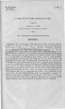
| dcterms.alternative.title | Motion for authorizing manuscript maps of Ohio, Indiana, Illinois, Missouri, Mississippi, Alabama and Louisiana, and territories of Michigan, Arkansas, and Florida | |
| dc.description.congressSession | 23-2 | |
| dc.description.johnsonAnnotation | Resolution of Senator Poindexter. [267] For the preparation of maps of the states and territories on the northwestern frontier, indicated lands to which Indian title has not yet been extinguished. | |
| dc.description.johnsonReference | 1835-1 | |
