| dc.contributor.author | Paine, Jack W. | |
| dc.coverage.spatial | Oklahoma | |
| dc.coverage.spatial | Pontotoc County. | |
| dc.date.accessioned | 2019-06-05T17:00:17Z | |
| dc.date.available | 2019-06-05T17:00:17Z | |
| dc.date.created | 1958. | |
| dc.date.created | 1958 | |
| dc.date.issued | 1958. | |
| dc.identifier.uri | https://hdl.handle.net/11244/320285 | |
| dc.description | Thesis (M.S.)--University of Oklahoma, 1958. | |
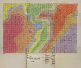
| dc.description | Nine maps in pocket. | |
| dc.description | Includes bibliographical references (leaves 44-46) | |
| dc.description | Main, cop. 1-2. | |
| dc.description | Geology, cop. 3. | |
| dc.description | wn/kw | |
| dc.format.extent | v, 46 leaves : | |
| dc.format.medium | v, 46 leaves :ill., maps ;29 cm. | |
| dc.language.iso | eng | |
| dc.subject.lcsh | Geology Oklahoma Pontotoc County. | |
| dc.title | The subsurface geology of T.4N., R.4 & 5E., Pontotoc County, Oklahoma / | |
| dc.type | Text | |