| dc.contributor.advisor | Buchanan, Austin | |
| dc.contributor.author | Bunting, Elizabeth Grace | |
| dc.contributor.other | Wentz Research Scholars | |
| dc.date.accessioned | 2019-05-08T15:57:33Z | |
| dc.date.available | 2019-05-08T15:57:33Z | |
| dc.date.issued | 2019-04-26 | |
| dc.identifier | oksd_Wentz_2019_buntingE | |
| dc.identifier.citation | Bunting, E. G. (2019, April 26). Optimizing the compactness of political districts in Oklahoma. Poster session presented at the Oklahoma State University Wentz Research Scholars Symposium, Stillwater, OK. | |
| dc.identifier.uri | https://hdl.handle.net/11244/319607 | |
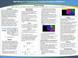
| dc.description.abstract | This work explores a mathematical optimization model to determine the optimal political districts for a state. Originally created in 1965 by Hess et al, the model assigns each population unit (such as a county) in the state to a population unit that is designated by the model to be the district center. In this way, it determines optimally compact political districts. Compactness is based on two constraints: the distance between a population unit and the population unit that is its potential district center, and the population of each county. | |
| dc.description.abstract | This work applies the Hess model to Oklahoma, using Python and Gurobi to implement the model. ArcMap was used to visualize the results of this implementation. In addition to applying the Hess model to Oklahoma, this work explores the effect of population bound variations in each district. Political districts should be as equal as possible, especially congressional districts (the focus of this research). However, this model does not allow exact equality. Therefore, experimentation was required to determine the level of population equality that also allowed the districts to be connected (another requirement of political districts). In addition, visual compactness is compared with population-weighted compactness. Because the population is a variable included in the objective function, it has a significant effect on the results of the model. If population is removed from the objective function, the district compactness is defined entirely by distance. | |
| dc.description.abstract | Through my research, I created a Python program that calculated optimal political district centers for Oklahoma and assigned each county in Oklahoma to its ideal center based on distance between and population of the counties. I also created a map in ArcGIS to visualize the districts created from this program. In addition, I experimented with the parameters and constraints included in the program to determine their effect on the districting solution. | |
| dc.description.sponsorship | Lew Wentz Foundation | |
| dc.format | application/pdf | |
| dc.language | en_US | |
| dc.publisher | Oklahoma State University | |
| dc.rights | The author(s) retain the copyright or have the right to deposit the item giving the Oklahoma State University Library a limited, non-exclusive right to share this material in its institutional repository. Contact Digital Resources and Discovery Services at lib-dls@okstate.edu or 405-744-9161 for the permission policy on the use, reproduction or distribution of this material. | |
| dc.title | Optimizing the compactness of political districts in Oklahoma | |
| osu.filename | oksd_Wentz_2019_buntingE.pdf | |
| dc.description.department | Industrial Engineering and Management | |
| dc.type.genre | Presentation | |
| dc.type.material | Text | |