| dc.contributor.advisor | Jacob, Jamey D. | |
| dc.contributor.author | Bunting, Lydia M. | |
| dc.contributor.author | Jacob, Jamey D. | |
| dc.contributor.other | Wentz Research Scholars | |
| dc.date.accessioned | 2019-05-08T13:02:45Z | |
| dc.date.available | 2019-05-08T13:02:45Z | |
| dc.date.issued | 2019-04-26 | |
| dc.identifier | oksd_Wentz_2019_buntingL | |
| dc.identifier.citation | Bunting, L. M., & Jacob, J. D. (2019, April 26). The calm before the storm: Comparing the initial stages of tornadic vs. non-tornadic supercells. Poster session presented at the Oklahoma State University Wentz Research Scholars Symposium, Stillwater, OK. | |
| dc.identifier.uri | https://hdl.handle.net/11244/319592 | |
| dc.description.abstract | Supercells are one of the most dramatic displays of weather in Oklahoma, and it is from this type of storm that the majority of tornadoes are produced. But while most tornados are produced by supercells, not every supercell storm produces tornadoes. Many supercells form and dissipate with processes almost identical to those that produce tornadoes but either the tornado does not form or it never reaches the ground. While these storms still pose threats to life and property, it is important to be able to better predict which supercells will produce tornadoes and which ones will not. Therefore, the question to be addressed by this project is which parameters differ between tornadic supercells and tornadic supercells and how those parameters might affect whether or not a tornado will form. | |
| dc.description.abstract | In order to better understand what conditions might influence the formation of tornadoes I studied both tornadic and non-tornadic supercells. This work was done primarily through the use of computational models using the Cloud Model (CM1) code and the high performance computing system at Oklahoma State University. CM1 is a program that was designed to model small-scale atmospheric processes and can be customized to simulate many instances of severe weather. For this project I used CM1 to model a nontornadic supercell and a tornadic supercell thunderstorm using a combination of preconfigured code and soundings collected by the National Weather Service in Norman, Oklahoma during a storm that took place El Reno on May 31, 2013. | |
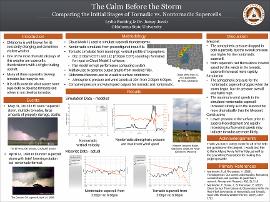
| dc.description.abstract | The next step was to compare the simulated storms to data collected directly from storms. Using the WeatherScope software available through the Mesonet website I generated graphs displaying atmospheric pressure and wind speeds for a nontornadic supercell and a tornadic supercell. From this comparison I saw that the pressure was almost 10 millibars higher throughout for the nontornadic supercell when compared to the tornadic supercell. These results indicate that very low pressure prior to the formation of a supercell means that tornados may be more likely to form. | |
| dc.description.sponsorship | Lew Wentz Foundation | |
| dc.format | application/pdf | |
| dc.language | en_US | |
| dc.publisher | Oklahoma State University | |
| dc.rights | The author(s) retain the copyright or have the right to deposit the item giving the Oklahoma State University Library a limited, non-exclusive right to share this material in its institutional repository. Contact Digital Resources and Discovery Services at lib-dls@okstate.edu or 405-744-9161 for the permission policy on the use, reproduction or distribution of this material. | |
| dc.title | Calm before the storm: Comparing the initial stages of tornadic vs. non-tornadic supercells | |
| osu.filename | oksd_Wentz_2019_buntingL.pdf | |
| dc.description.department | Mechanical and Aerospace Engineering | |
| dc.type.genre | Presentation | |
| dc.type.material | Text | |
| dc.subject.keywords | meteorology | |
| dc.subject.keywords | supercell | |
| dc.subject.keywords | tornado | |
| dc.subject.keywords | storm | |
| dc.subject.keywords | weather | |